|
John L's Old Maps / Supplementary Pages: Views of the Apostle IslandsPage II:
|
|
 See the MENU
 |
On September 26, 2007, as the last of the scheduled events of the yearly Apostle Islands Lighthouse Celebration, a small group of intrepid explorers was whisked from Bayfield on the Ashland Bay Express tour boat to an offshore point near the LaPointe Light on historic Long Island. From there we rode to shore in a rubber boat and then began a hike to check out both lighthouses that are still in operation as automated beacons. For the past couple decades, Long Island has been an extension of Chequamegon Point – a long, narrow and sandy peninsula nearly enclosing the Chequamegon Bay of Lake Superior just north of Ashland, Wisconsin. When and if Long Island becomes an island again depends on the dynamic nature of Lake Superior whose shoreline along the islands and mainland is not entirely set in stone. Indeed, the south shoreline of Long Island continues to erode while the beach along the north shoreline constantly builds up. This land mass thus appears to be inching toward Madeline Island, just to the north. |
||
 1 |
 2 |
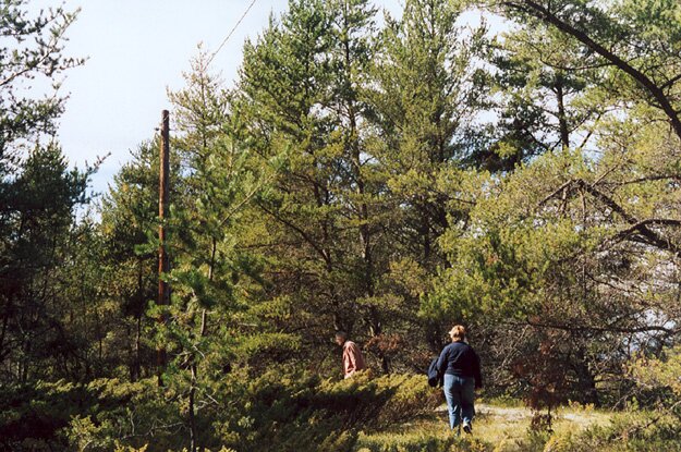
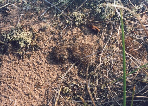
1: This is the LaPointe Light Tower, built in 1897 about a mile from the western tip of Long Island where the other light station on our itinerary was built the same year. Both light stations were the successor to the old LaPointe Light which had been built around 1858-59 at a location between the two later sites. 2: Here we are heading west on one of the several well-trodden paths that run roughly parallel to each other between the two light stations. Any trace of the old concrete sidewalk that was built over a century ago to ease the walking difficulties of the lighthouse keepers appears to be gone – totally obliterated by the shifting sand and the build-up of vegetation. (I had been hoping to get a ground-level movie of at least a portion of the sidewalk being used presently.) 3: The remains of an old oil storage building. 4: A high ridge running parallel to the northern shore about a hundred yards away – possibly having originated as a sand dune along the beach which ran along here many decades ago. The Ashland Bay Express can be seen in the distance. 5: One of my fellow hikers pointed out patches of cryptobiotic soil along the path near the beach where the vegetation was relatively sparse. Once again the thought of a bull in a china shop came to mind, and "tread lightly and carefully" became the rule in such areas. 6: The beach along the north shore, about a half mile west of the 1897 LaPointe Light tower. 7: Looking northerly and seeing Bayfield in the distance toward the left. LaPointe on Madeline Island is barely visible in the center of the photo. A couple more views of both towns are shown here and here as we make our way to the western tip of Long Island. 8: A small pond near the western tip. 9: We reach our destination: The Chequamegon Point Light – originally built in 1897 and more recently moved from the eroding shoreline to a point further inland. It has been joined by a "D9 Tower" which presently houses the beacon at this site. 10: The Chequamegon Point Light was moved with considerable difficulty to its present location by means of a Coast Guard helicopter. The original foundations are shown in this photo very near the shoreline. (I'm a couple feet off-shore taking this photo.) 11: A close-up of one of the original foundation stones. 12: Another view of both structures as we round the point and look roughly northward. 13: A magnified view of the Chequamegon Point Light showing work in progress to stabilize the structure. This is indeed a hazardous area that is well-marked to keep visitors at a distance. On the morning of September 20, 2008, a tour of the recently-renovated Raspberry Island Lighthouse was conducted. This was the last of the tours for this year's Apostle Islands Lighthouse Celebration. While the lights farther out in the lake (on Sand, Devils and Outer Islands) were set there to warn ships of the dangerous shallows and currents among the islands, the original intent of the Raspberry Island Lighthouse was to help ships enter the West Channel to reach the ports of La Pointe, Ashland, Bayfield and Washburn. Historically these ports were important centers of commerce, and while Ashland still trades via the lake, the general area has become recognized around the world as an important hotbed for tourism. And small wonder. You gotta see it to believe it, and we only scratch the very surface on these web pages. 14: Threading its way up the West Channel – between the Bayfield Peninsula mainland and several of the Apostle Islands – the Ashland Bay Express reaches Raspberry Island. 15: Here is Ranger Jim, the first person you see on the dock as you arrive. An identical photo can be taken as you leave the dock on your return trip. 16: A view of the lighthouse building from the dock. 17: Ranger Jim gives our group an introductory lecture on the history and geography of Raspberry Island and impresses upon us our duty to preserve its integrity. Among the things to know: There are the necessary outdoor facilities which one may use as needed, but there are absolutely no trash cans on the island. One must not leave one bit of garbage anywhere – nor one crumb of food for that matter. That which satisfies humans is probably antinutritional to the animals. Cell phones do not work on the island. Therefore, we are truly free! 18-20: A path runs approximately 0.8 miles from the lighthouse to the sandspit on the other side of the island. 21: Geographically, the sandspit is like a V-shaped point that points to the southeast – with a beach on each side of the "V" and at the point. Here we are looking across the West Channel to the mainland. 22: Having rounded the point and now looking toward the northeast, we see Bear Island (the dark mass toward the left) and Otter Island (to the right). In the center of the photo is the relatively distant Rocky Island. 23: At the same spot and turning toward the southeast, we see the very tall Oak Island on the left, and the mainland shows up in the distance on the right. In between is the West Channel. 24: This is essentially the same view as Photo 23 (i.e., toward the southeast). This time we have rounded the point of the sandspit on the way back to the lighthouse. 25: Again looking through the West Channel with Oak Island on the left and the mainland on the right. Here we are on top of the lighthouse building. 26: More island spotting as we look west from the lighthouse tower: The land mass on the left is the mainland. Then, in order (and from far to near), we see Eagle, Sand and York Islands. Next time I visit this place, I must (somehow) get a suitable photo of the spiral staircase and ladder one has to climb in order to access the tower. 27: In the lighthouse building, Ranger Audrey points out some of the antique furnishings. Now that the lighthouse tour season is over, things have been packed away till next year. 28: Along the stairs between the dock and the lighthouse station are the rails of the historical tramway which was used to haul building materials and coal to the station. 29-30: A couple parting shots from the edge of the bluff. The white structure on the left in Photo 30 is the solar-powered light that is presently in operation. The original lens of the lighthouse is now on display at the Madeline Island Historical Museum in La Pointe.
|
 3 |
 4 |
|
 5 |
 6 |
|
 7 |
 8 |
|
 9 |
 10 |
|
 11 |
 12 |
|
 13 |
 14 |
|
 15 |
 16 |
|
 17 |
 18 |
|
 19 |
 20 |
|
 21 |
 22 |
|
 23 |
 24 |
|
 25 |
 26 |
|
 27 |
 28 |
|
 29 |
 30 |
|
|
" More Apostle Islands photos: |
This page is best viewed at 640X480 or wider. All photos on these pages are by myself unless noted otherwise. This page was last modified on 9/29/08 at 5:30 PM, CDT. John Lindquist: homepage, complete site outline. University of Wisconsin – Madison |
|
|
Spaces inserted into email address to discourage spambots. Please remove before using! |
||